

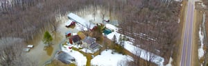
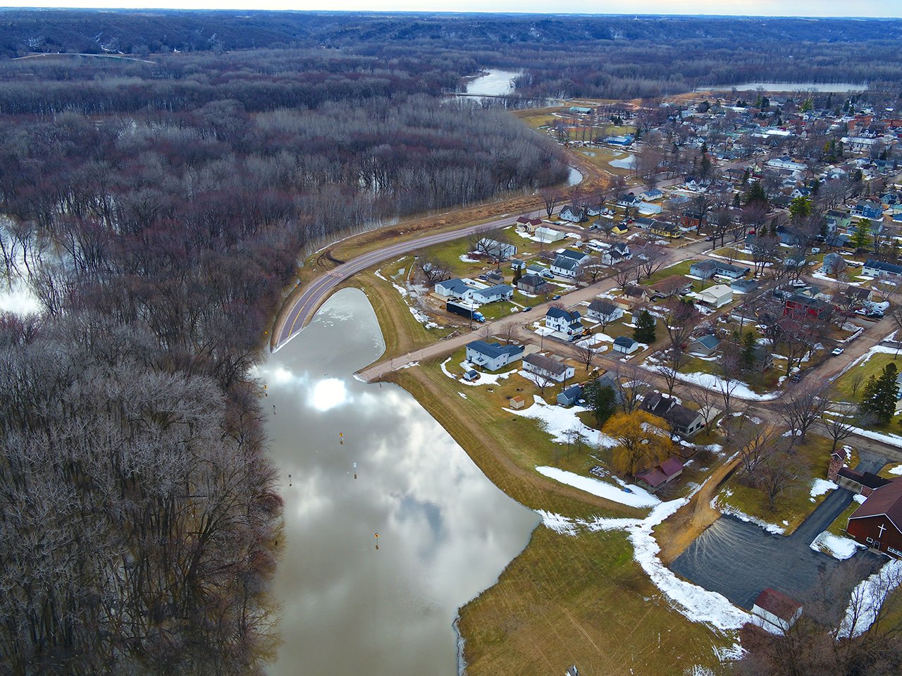
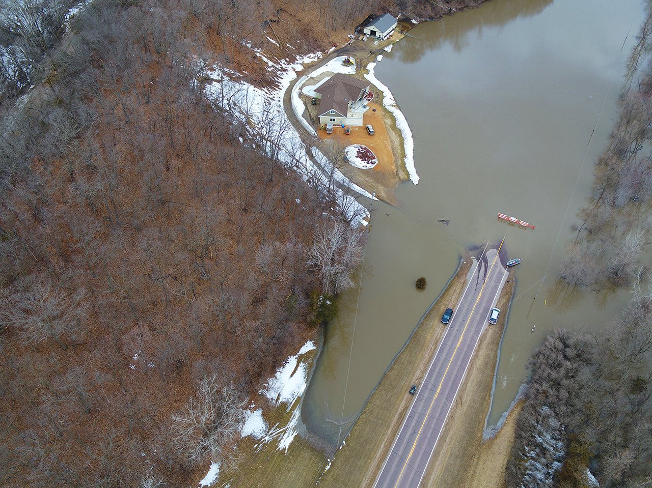
Flooding is often a major concern for communities across the United States. Wet fall conditions that leave soil moisture above normal, a relatively deep frost, and near record snowpack conditions can contribute to flood events.
These elements alone can set the stage for significant flooding. But a changing climate can compound the issue with heavy rainfall, rapidly melting snow, or ice jams that can push rivers and streams rapidly to major flooding. We are seeing that you don’t have to live in a Federal Emergency Management Agency (FEMA)-mapped flood zone to experience flooding – it can happen nearly anywhere.
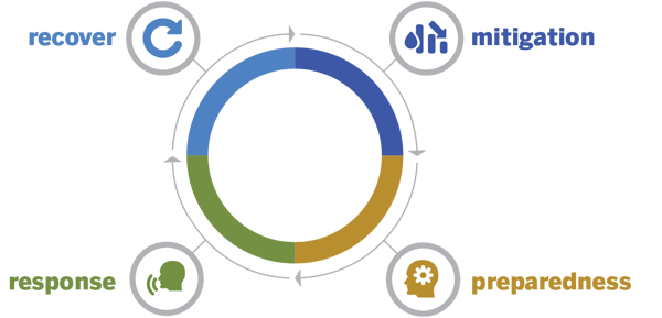
You can’t control Mother Nature. So, what CAN you do to minimize flood risk? Don’t wait until it's too late, be proactive, and implement an emergency flood management plan. The four phases of an emergency flood management plan are: mitigation, preparedness, response, and recovery. Each phase is examined more closely below.
1. Mitigation:
Mitigation activities are intended to significantly reduce or even eliminate the risk of flooding before it occurs. The following list includes some common mitigation activities:
- Review and update building codes and zoning. Responsible community planning can be one of the most powerful tools to minimize flood risk. Communities should consider going beyond traditional standards and FEMA or State mandated minimum levels of protection for new buildings or critical infrastructure and designate open space uses in flood-prone areas. If a community participates in FEMA’s Community Rating System, these activities can result in flood insurance premium reductions for property owners within the community.
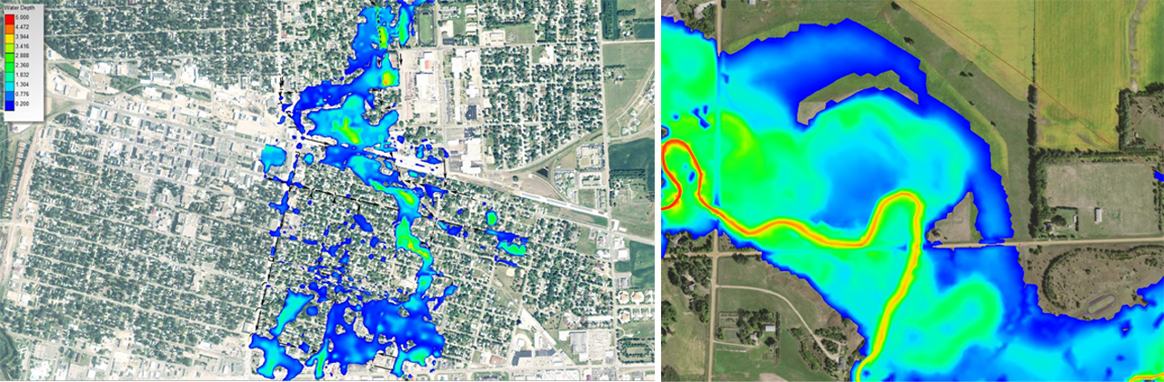
- Conduct a vulnerability analysis. Hydrologic and hydraulic modeling programs can help estimate current flood risk and potential future risk with climate induced changes while presenting the data in an easy-to-understand graphical format. These flood modeling toolboxes include many resources to choose from, helping to identify the appropriate level of detail for each request. The modeling produces maps that indicate where flood-prone areas are located, which can then be confirmed with past observations and used to evaluate alternatives to minimize flooding.
- Implement Geographic Information Systems (GIS). By using GIS capabilities to develop infrastructure and natural resources databases, you can document historic and existing conditions of stormwater management systems and natural streams alike. This information can serve as the foundation for hydrologic and hydraulic modeling, and even provide an inventory of the community's assets and infrastructure most vulnerable to flooding.
- Implement mitigation projects. Projects that focus on improving stormwater management or reducing flood risk from a major river can be effective ways to mitigate flooding. These projects include traditional and innovative practices, and can consist of levees, floodwalls, impoundments, improved conveyances, wetland restoration, acquisition of flood-prone properties, and even stormwater harvest and reuse. Water resources engineers can combine their experience with new data and tools to identify the best flood mitigation practice for every community.
- Provide public outreach and education. On a national level, much work has been done in recent years to develop accessible and easy-to-use tools for estimating and understanding flood risk. If your community isn’t included in the databases used for these tools, work with your consultant to develop similar decision-making tools. Some examples of publicly available resources include:
- FEMA’s Hazus: a tool used to support risk-informed decisions by estimating potential losses from natural disasters such as flooding.
- FEMA’s IMMERSED: a virtual reality experience about flood and resilience.
- USGS’s Flood Inundation Mapping (FIM) Program: includes not only inundation maps, but also streamflow conditions, flood forecasts, and potential loss estimates.
Your consultant can best recommend which tool would most help your city prepare depending on your unique situation.
2. Preparedness:
Preparedness activities are intended to achieve a sense of readiness for the flooding emergency. There are several ways to get ready:
- Develop a plan. Emergency preparedness plans should be tailored to address the specific needs of the community. Communities are required by FEMA to develop a hazard mitigation plan and update it every five years, but that doesn’t mean you’re covered. Engage neighboring communities and all parties expected to contribute to the response process so they can provide useful feedback and understand their role. Ensure flooding related issues and projects are identified in the plan to ensure eligibility for FEMA related funding programs.
- Practice makes perfect. Conduct an emergency exercise to identify deficiencies in your plan and update it accordingly. Like the planning process, engage neighboring communities who can provide mutual benefits by sharing and/or swapping critical resources. Games have even been developed to make this activity more enjoyable and effective.
- Utilize emergency warning systems. Learn what information is available to help you predict flooding conditions. With an extensive network of stream and precipitation gauges throughout the country, it is likely that publicly available information can be used to help your community.
- Consider purchasing flood insurance, if it’s not already a requirement! Flood insurance can be purchased by anyone whose property is within a community that participates in the National Flood Insurance Program (NFIP). You do not need to be within a FEMA-mapped floodplain to be eligible. However, if you wait until the water is inches from flowing into your building, you’re probably too late. There is a 30-day waiting period from the date of purchase until your flood insurance policy goes into effect – here are a few exceptions:
- There will be a one-day waiting period if a building is newly designated in the high-risk Special Flood Hazard Area (SFHA) and flood insurance is purchased within 13 months of a map revision.
- There will be no waiting period if flood insurance is purchased while making, increasing, extending, or renewing a mortgage loan.
- Contact your insurance agent for additional information.
- Document existing infrastructure. According to one SEH client, accurate GPS data of their existing storm sewer system enabled them to make sure inlets were cleared ahead of the recent rainfall events. The preventative measure averted numerous homes from flooding while helping to save money.
- Provide proper maintenance. Make sure drainage structures are cleared to allow water to be intercepted and conveyed as intended. This may mean removing ice and snow from storm sewer inlets, moving snow piles that may inadvertently act as dams, and clearing culvert ends, among other activities. Of course, these actions should be done with proper equipment and safety precautions.
- Stockpile materials. Your community’s emergency response plan should identify materials needed to respond to several types of emergencies. In the case of flooding, these materials typically include pumps, sandbags, and earth fill for temporary levees, but it should also include food, water, and clean-up kits.
3. Response:
The response phase of emergency flood management involves providing immediate assistance, such as emergency relief and search and rescue. The specific activities of this phase depend on the community’s characteristics, but the primary goal is to meet people’s basic needs until recovery begins.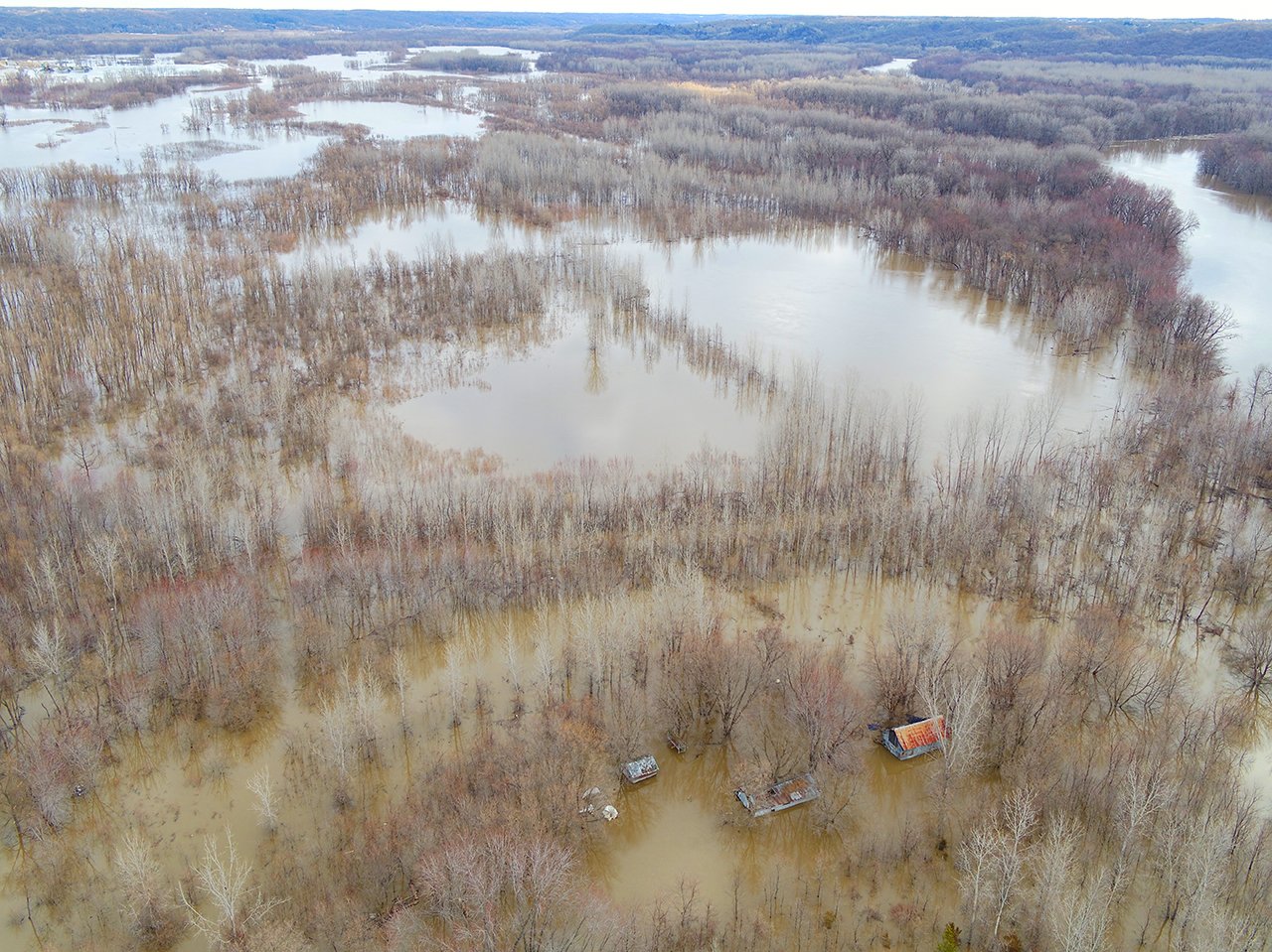
4. Recovery:
Typical recovery actions bridge the gap between emergency and normalcy. These actions can include providing temporary housing, reconstruction, event counseling, and education. The following two activities are often forgotten during recovery, but can be greatly beneficial to the community:
- Apply for Grants. FEMA’s Hazard Mitigation Assistance (HMA) grant programs provide funding opportunities for disaster mitigation both before and after events. FEMA administers the following grant programs:
- Hazard Mitigation Grant Program (HMGP) helps implement long-term hazard mitigation planning and projects after a presidential major disaster declaration.
- Pre-Disaster Mitigation Program (PDM) funds hazard mitigation planning and projects annually.
- Flood Mitigation Assistance Grant Program funds projects and planning that specifically aim to reduce or eliminate long-term risk of flood damage to structures insured under the NFIP.
- Building Resilient Infrastructure & Communities Program (BRIC) shifts the federal focus away from reactive disaster spending and toward research-supported, proactive investment in community resilience.
- Document the flood. After the flood waters have receded and it is safe to do so, mark high water lines and survey them to document the maximum flooding condition. Interview residents and business owners to collect information about their experience with the flood and the impact it had on them. Videos and photographs taken during the flood can also be useful but should only be taken from a safe location. With the increased use of drones, consider their use in documentation. All information collected can be used to justify the need for financial assistance, public education on the severity of the event, and improve the accuracy of flood modeling.
To sum up
It’s important to identify and implement strategies to minimize flood risk. From industry-leading software flood simulators to GIS capabilities for documentation, today’s resources can help your community prepare for tomorrow’s uncertainty.
About the Author

Brad Woznak is a Senior Professional Engineer, Professional Hydrologist, and Certified Floodplain Manager specializing in water resources and hydraulic engineering at SEH since 1997. Brad has been involved with floodplain management and administration for communities across the Midwest and has been honored with numerous Engineering Excellence Honor Awards throughout his career.

*Registered Professional Engineer in MN, WI, IA, NE, CO, SD, IN