
Drone Services
Do More with Drones
See the solutions: Expertise to elevate and expand your projects.
Our team of drone technology experts will develop a plan of services based on your project needs and outcomes. From videography, photography, construction documentation, inspections, visualizations, and mapping using LiDAR, photogrammetry, and orthomosaic capabilities, we’re ready to help you successfully design, plan, and showcase your vision.
Every SEH pilot is FAA certified and trained specifically for construction and engineering sites, with an additional wealth of experience navigating environmental and natural resource settings. We’re dedicated to safely delivering cost-effective, time-saving solutions.
“In the midst of the pandemic, our Outreach and Education program was looking for new and creative ways to reach residents remotely. SEH’s drone crew was critical in supporting our efforts to create beautiful and informative educational videos. The result has been a much-utilized online outreach program.”
– La Crosse County Landfill
Specialized Services
Confined Spaces
Access hard-to-reach areas with ease
Mapping
Plan and design smarter with photogrammetry, LiDAR, and orthomosaic images
Videography
Share the story of your project
Visualizations
Envision your future infrastructure
Construction Documentation
Capture consistent progress
Safe Inspections
Review remote and risky areas
A Smart Solution for Confined Spaces
Inspect those hard-to-reach areas safely, efficiently, and precisely.
Efficiency
Drones with cutting-edge sensors such as LIDAR gather high-resolution data quickly and accurately, saving time on site and reducing downtime or interruptions during inspections.
Safety
Deploying drones significantly reduces reliance on people to enter confined, high-risk areas, lowering the chance of accidents or contact with dangerous conditions.
Cost-effectiveness
Using drones to inspect confined spaces can result in significant long-term savings by minimizing reliance on specialized technicians and equipment while also cutting down data collection time.
Accessibility
Drones can navigate areas that are otherwise unreachable in confined spaces, allowing for thorough inspections and data gathering in places where it's challenging or impossible for humans to enter.

Drone-mounted cameras and sensors allow SEH’s experienced team to collect ground surface elevation data and georeferenced aerial photographs of project sites – an important resource during the project planning and design process. These powerful tools offer your team the visuals and data to address stakeholder questions and concerns.
Our mapping capabilities include:
- Stockpile volumetric measurements and analysis
- Ground surface topography
- Tree and vegetation measurements for airport runway surface obstruction analysis
- Aerial photography for use in CAD and GIS
- 3D scanning of structures
Projects in Action
Interstate Island, MN.
Drones captured photogrammetry (orthomosaic) footage for use during this project to protect shorebird habitat.
Northwest of Medora, ND.
LiDAR drone footage was used to capture data for a watershed study.
Roaring Fork Bridge, CO.
3D Scanning was used to collect data of existing structure for future project development.

Project videography reaches far beyond unique views and sweeping visuals from above; it can play a key role in stakeholder engagement by weaving together expert interviews, compelling data, and clear imagery to convey the full story of your project. See how pairing drone and ground footage can successfully come together to engage your intended audience.
“We worked with SEH for drone services over our brand-new intersection art piece. Bailey was attentive and intentional about the multitude and perspective of shots she took throughout the day. We are very impressed with the quality of the hyper-lapses and photos and will be able to use them for a multitude of uses throughout the City. Would recommend SEH’s drone services!”
– City of River Falls Management Analyst
Projects in Action
10th Avenue Bridge, Minneapolis, MN.
Capturing progress throughout, this two-year construction project was documented via drone.
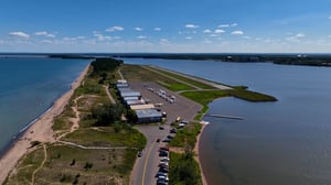
South St. Paul Airport, South St. Paul, MN.
Drones captured each stage of this 18-day runway reconstruction.
Frieden Development, Fredericksburg, TX.
Drones captured the picturesque landscape of this first-of-its-kind community, offering a feeling of home for marketing purposes.
Barnes Road, Colorado Springs, CO.
Interview, aerial, and street footage was shot via drone to document this project connecting a residential area with a bustling state highway.

Don’t tell, show your audience what the completed project will look like with visualizations overlaid with drone footage. Create several options for stakeholder input showing alternate components and additions. Visualizations help your audience see what you know is possible, painting the picture of project success and helping throughout the permitting, project design, and public engagement process.
Projects in Action
37th Avenue NE Design Opportunities, Minneapolis, MN.
Drones captured aerial footage for use in a proposal to show design ideas.
185th Street Improvements, Lakeville, MN.
Drone footage provided preliminary 3D visualization for proposal, public outreach, and project website use.

One of the simplest yet most valuable deliverables to keep your clients, stakeholders, and project teams up to date and engaged is consistent construction documentation. Your progress will be conclusive with photos and 360 panoramas of your desired frequency. All data can be separated by date and easily included in update emails, newsletters, and other promotional and communication material.
Projects in Action
Lake Elmo Airport Runway 14-32 Relocation, Lake Elmo, MN.
Drones captured weekly panos during construction for multiple years that was used in construction newsletters.
STH 35/US 14, La Crosse, WI.
Drones captured monthly progress updates of this road reconstruction with 360 panos.
Twin Ports Interchange, Duluth, MN.
This ongoing, multi-year project provides regular project updates with panos.

Inspections often come with a number of challenges, especially if crews need to take extensive safety precautions to simply reach the target area. Rather than scaling a cell tower, relying on a snooper truck, being surrounded by heavy traffic, or dealing with inclement weather, our drones team reliably inspects those hard-to-reach areas safely, efficiently, and precisely.
Projects in Action
Georgetown Loop Bridge, Georgetown, CO.
Drones were used to inspect the Devil’s Gate Bridge on the Georgetown Loop Railroad, safely capturing footage mere inches from the structure.
Telecommunication Tower Inspection, White Bear Lake, MN.
Drones captured footage of this telecom tower from various angles, ranges, and perspectives.
Future Project Need? Contact Us!
To speak with a member of our team or learn more about our services, please fill out the contact form.
Insights
How Drones Are Changing Confined Space Inspections
How the Use of Drones for Reality Capture is Expanding Our Horizons
How Drones, Webcams and Construction GIS Can Help Accelerate Your Project
Technology's Rising Role in Key Project Phases
How to Plan and Deliver a Better Engineering Project [eBook]
Subscribe to our eNewsletter today for the latest updates, project highlights, and industry perspectives.